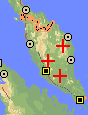
Range of Dacrydium comosum (1). Adapted from a map by
www.expediamaps.com
Common Names
Taxonomic notes
Description
"Shrub c. 2-4 m tall, 5 cm diam., on exposed ridge, to a tree at least 12 m tall. Densely branched with branches all turning upward and the aggregated tufts forming a nearly flat to umbrella-like crown. Juvenile leaves spreading perpendicular to the branch and then curving forward ± parallel with the branch, pungent, lanceolate, up to 33 mm long and c. 0.8 mm wide at the base, 0.2 mm thick, sharply keeled on the dorsal side, nearly flat or slightly concave on the axial side. Adult leaves similar to juvenile leaves except that the upper part is usually straight so that the apices are directed somewhat outward, 12-20 mm long, 0.6-1 mm wide but slightly expanded at the basal attachment, 0.2 mm thick. Fertile structures mostly lateral, subtended by a small cluster of reduced leaves which are c. 4 mm long. Pollen cones 8-10 mm long and c. 3 mm diam.; apex of the microsporophyll a narrow lanceolate spur 1.5-2 mm long and c. 0.5 mm wide. Seed-bearing structure consisting of several lanceolate bracts c. 2 mm long, one or two of which are usually fertile. The light brown, fully exposed seeds are 4-5 mm long" (1).Range
Malaya. "[K]nown only from the crest separating Selangor and Pahang and on the G. Tahan massif; Pine Tree Hill; Ulu Kali; Ginting Highland... On exposed ridges as a local dominant in stunted mossy forest between 1440 and 2200 m" (1).Big Tree
Oldest
Dendrochronology
Ethnobotany
Observations
Remarks
Citations
(1) de Laubenfels 1988.See also:
Dallimore & Jackson 1967.
Silba 1986.
de Laubenfels 1969.
[Dacrydium] [Podocarpaceae] [home]
This page is from the Gymnosperm Database
URL: http://www.geocities.com/RainForest/Canopy/2285/po/da_m/comosum.htm
Edited by Christopher J. Earle
E-mail:earlecj@earthlink.com
Last modified on 29-Jan-1999