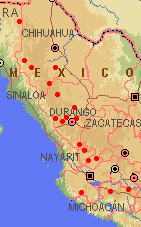
Range of Pinus durangensis (1). Adapted from a map by
www.expediamaps.com
Common Names
Taxonomic notes
Syn: Pinus durangensis forma quinquefoliata Martínez 1948; Pinus martinezii Larsen 1964; Pinus douglasiana var. martinezii (Larsen) Silba 1990 (1).Description
Range
Mexico: E Sonora & Chihuahua (rare), Durango, Zacatecas & N Jalisco (common), and scattered S through Jalisco & Michoacán. Its distribution is mainly through the S Sierra Madre Occidental, where it occurs at (1400-)1600-2800(-3000?) m elevation. At the lower elevation limits it may be found with Juniperus deppeana and Pinus oocarpa ; higher, it occurs in pure stands, in mixed pine forest with P. arizonica, P. leiophylla , or P. engelmannii as codominants, or in pine oak forests. At the upper limits of its distribution it can be found with Cupressus lusitanica and/or Abies [species not specified]. Other associated pines include P. montezumae , P. teocote , and in Michoacán, P. ayacahuite (1). See also (2).Big Tree
Oldest
Dendrochronology
Ethnobotany
Observations
Remarks
Citations
(1) Farjon & Styles 1997 .(2) Robert S. Thompson, Katherine H. Anderson and Patrick J. Bartlein. 1999. Atlas of Relations Between Climatic Parameters and Distributions of Important Trees and Shrubs in North America. U.S. Geological Survey Professional Paper 1650 A&B. URL= http://greenwood.cr.usgs.gov/pub/ppapers/p1650-a/pages/conifers.html , accessed 22-Jan-2000.
[ Pinus ] [ Pinaceae ] [ home ]
This page is from the Gymnosperm Database
URL: http://www.geocities.com/RainForest/Canopy/2285/pi/pin/durangensis.htm
Edited by Christopher J. Earle
E-mail:
earlecj@earthlink.com
Last modified on 24-Jan-2000